Next release is Nov 8
Author Archives: heikki
Cycle 1810 released
Next release is Oct 11
Cycle 1809 released
Next release is Sept 13
Cycle 1808 released
Next release is Aug 16
Cycle 1807 released
Next release is July 19
Cycle 1806 released
Next release is June 21
SkyCharts v5.4.5 released
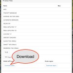
Now you can download A/FD and approach plates on an airport basis
v5.4.5 gives you the choice of the usual EVERYTHING option (you get plates for all airports in the same region) and the option of just download the A/FD and approach plates for specific airports. Make sure you select the ‘Charts’ option in the download page, and not Everything. By doing this, you basically halve the total amount of data to download. Please make sure you have downloaded the plates you intend to use before going airborne, as it will obviously be impossible to download in the air!
Also, we have included a fix for user defined waypoints. Please check Q23 in the FAQ for the syntax.
http://skycharts.net/faq.html
SkyCharts v5.4.4 released
*Moved subscription info to the top and the GDPR to the bottom on the Subscription page in order to easier find info on smaller devices.
*Built in 1805 database
Cycle 1805 released
Next release is May 24
SkyCharts v5.4.3 released
*GDPR updates
*METAR/TAF now stays up even when map is moved
*Built in 1804 database


